Clouds of the Day - Fountains in the Sky - Thursday, November 2, 2023

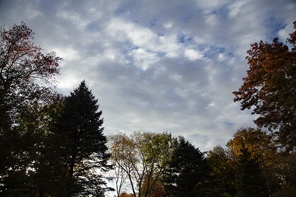
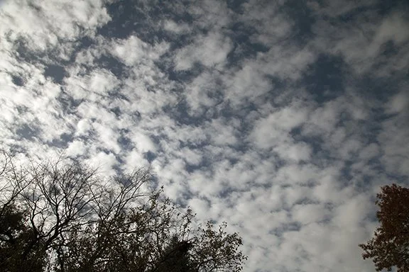
This layer of Altocumulus covered much of the sky for part of this afternoon. Each individual cell features a pillow-like cloud separated from its neighbors by a thin blue line of sky or a line of suppressed cloud cover. The pattern fills this photo.

Each ‘pillow’ cloud forms at the top of a fountain of rising air. The surrounding line of blue sky or suppressed cloud is where the vertical motion air is down, not up. The ‘pillow’ forms where the column of rising air reaches its condensation level and forms a cloud. The cloud layer is thin because the air above the cloud is stable and moving down. The air stops rising at the top of each cloud and spreads out and sinks creating the pattern of ‘pillow's.

The up and down vertical air motions are likely moving only a few inches per second. Compare that with a severe thunderstorm that may have updrafts that exceed 60 mph.

The photo below points out three individual cloud cells out of the hundreds visible in the cloud layer. The entire sky is filled with these cells which show us where columns of rising air are forming clouds and sinking air is clearing the sky around fountains of rising air. columns. The fountains are invisible except where the clouds have condensed. Each fountain is surrounded by a thin curtain of sinking air.

Altocumulus stratiformis - hundreds of cloud cells in a stratified layer, Hence the name
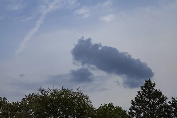
Altocumulus Floccus

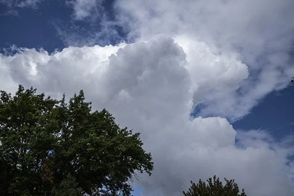
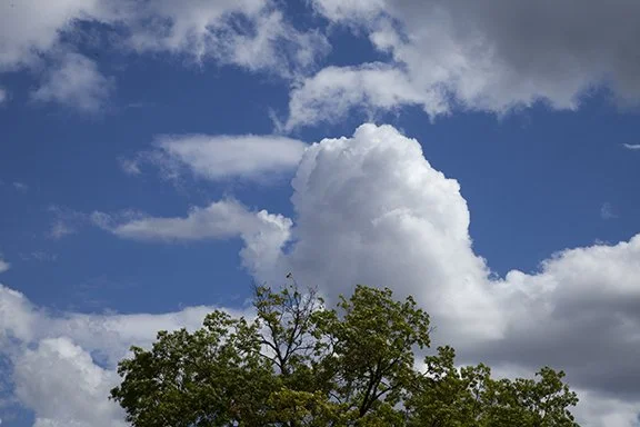
More examples of the ‘pillows’ caused by fountains of rising air in the middle levels.

Clouds of the Day - Favorable Impressions - Wednesday, November 1, 2023

Clouds come in many shapes, sizes, and patterns. Here is a selection of photos from today showing the variety of clouds types in our sky today. Superimposed on the clouds were wave patterns that were impressed on the clouds. The waves came in different sizes and wavelengths and added a great deal of interest to the sky.

Altocumulus

Altocumulus

Altocumulus, Altostratus

Altostratus, Altocumulus, and cirrus

A CONTRAIL and Cirrostratus

Altostratus and Altocumulus

Altocumulus

Altostratus and Cirrostratus

CONTRAILS and Cirrostratus

Clouds of the Day - Castles in the Sky - Monday, October 23, 2023

Altocumulus include some of the most interesting cloud formations. The photos below show the sequence of cloud formations from the late morning until early evening. The first seven photos show examples of Altocumulus castellanus and Altocumulus floccus. They form in a layer of conditionally unstable air in the middle levels between 6,500 ft to 20,000 feet (2,000 m to 6,000 m). Air is conditionally unstable when a lifting mechanism, such as rising motion due to an approaching front or lift caused by an approaching or leaving jet stream aloft. The lift causes the to rise until it becomes unstable and condensation occurs.

With a little imagination, castellanus look like the turrets found on castles, hence the reference to Castles in the Sky - Altocumulus castellanus.

The clouds below mostly various forms of cumulus. These also form when a lifting mechanism, such as a front, heating, or moisture moves into the area.

Altocumulus, Cumulus, (center to upper left) and cumulus congestus (middle right lit by the Sun)

Cumulus, cumulus congestus

Cumulus in rows

Cumulus in rows

Altocumulus floccus (shaped like flocks of wool).

Clouds of the Day - Cirrus and Ice Crystals - Sunday, October 22, 2023

All of the clouds in these photos are types of Cirrus clouds with fall streaks - bands of falling ice crystals precipitating from the clouds. The cirrus are in thick clumps (spissatus) that may include both ice crystals and water cloud droplets. As the top of the cirrus precipitate the dense head dissipates leaving only remnants of the original cloud as fibers or thin streamers that appear to be falling out of clear air.

Cirrus spissatus are dense clumps of high clouds usually above 20,000 feet. It has been estimated that about 50% of Cirrus spissatus are formed from the debris of past thunderstorm anvils. The other 50% form when convective rising motion forms dense localized convection at high levels. The convection cloud precipitates ice crystals that look like fibrous streamers. As the streamers persist the clouds gradually dissipate. See the several examples below.

Cirrus spissatus

Cirrus spissatus with fall streaks of ice crystals

Cirrus fibratus

Cirrus spissatus and Cirrus fibratus formed by convection intermingled with fall streaks of ice crystals.

Cirrus spissatus with fall streaks. Note the three birds circling at the left center of the photos. They appeared to be riding a thermal of rising air like gliders.

Clouds of the Day - Middle Level Clouds - Wednesday, 18 October 2023

This morning featured middle level clouds as a storm system centered in Minnesota move to the northeast dragging a cold front across the area. Clouds early in the day were Altocumulus floccus. The name comes from the Latin word floccus for its resemblance to tufts of wool. It indicates a thin layer of unstable air. The Altostratus dominated the mid morning to early afternoon sky. The flat layer cloud indicates there is weak upward motion creating these clouds. We did receive a few sprinkles of rain from the Altostratus.

Altocumulus floccus

Altostratus

Altostratus

Altostratus

The satellite image below reveals more about the clouds. At ground level all that could be seen was a mostly flat cloud layer. The satellite image shows the instability present with cellular clouds along the back northwest edge of the cloud band and over Kansas. That band is ahead of a cold front crossing Iowa.

The entire storm shape on the satellite image looks like a comma. The head of the comma is in the colder air aloft that is circulating counter clockwise around over South Dakota. The comma tail is the curved cloud band from Minnesota through Wisconsin and northwest Illinois, Iowa and on to northwest Missouri and Kansas. The comma head is rotating counterclockwise and the tail is moving east and northeast with individual clouds moving to the northeast.

GOES 16 11:51 a.m. October 18, 2023 Visible Satellite Image

Surface Map 11:00 a.m. Wednesday, 18 October 2023 plotted by Digital Atmosphere available at weathergraphics.com

The streamlines on the chart below show the wind direction at the surface associated with the storm. The surface low center is over northern Minnesota. The upper level low center is to the southwest over eastern South Dakota as shown on the satellite image.

Surface Streamlines, 11:00 a.m. Wednesday 18 October 2023, Plotted by Digital Atmosphere, www.weathergraphcis.com

Clouds of the Day - Cirrus - Tuesday, October 17, 2023

Looking south we see the solar disk being filtered by thin Cirrus fibratus with Cirrostratus in the low center of the photo.

Cirrus fibratus (top half) and Cirrostratus lower center. The light artifact is caused by sunlight interacting with the camera lens.

The next photo is more interesting than it may look. The thin cloud bands were not immediately visible to the naked eye. After taking the photo I could see the bands in the camera display. The thinnest streaks appear to radiate from a central point in the distance behind the tree in the lower right. They are classified as Cirrus fibratus radiatus because they radiate from a central point. There are at least five bands radiating from that point.

However, the bands do not radiate from the same point. It is an optical illusion. If you are riding in a car down a long straight road look down the road toward the horizon. The road seems to narrow to a point in the distance. This illusion occurs fairly often in the sky and is especially impressive when the bands go from one horizon to overhead then to the opposite horizon. The bands appear to come out of one point on one horizon, spread to their widest size overhead, then converge to a point on the opposite horizon. The real width of the bands is the width you see overhead. As you look toward the horizon the bands gradually narrow as the optical illusion stakes over.

The bands in the top photo do not appear to radiate from a point because I was not standing under the bands when the photo was taken and they did not appear to reach either horizon. If they are long enough you may see the convergence effect anyway.

Cirrus fibratus radiatus center behind the tree on the lower right. The thicker Cirrus (lower center and upper left) are cirrostatus because they turn into a small sheet layer cloud.

It is hard to know the altitude of these clouds. It would have been nice to have a commercial airliner fly through, in front, or behind the clouds for a reference.

Clouds of the Day - Cumulus - Monday, October 16, 2023

Cumulus clouds are puffy heaped clouds found at all three main levels in the atmosphere - low (below 6.500 feet), middle (between 6,500 feet to 20,000 feet, and high clouds (above 20,000 feet). In the low level they are named Cumulus. In the middle level they are Altocumulus. In the high level they are Cirrocumulus.

The clouds in the photo below are puffy and heaped low clouds and are therefore named Cumulus.

Photo copyrighted October 2023 by Craig Johnson.

Photo copyrighted October 2023 by Craig Johnson.

Photo copyrighted October 2023 by Craig Johnson.

Clouds of the Day - Stratus - Friday, October 13, 2023

Stratus is one of ten principle cloud types. It may be found at all of the three main cloud levels - low, middle, and high. Stratus is a layer cloud. Instead of being found in individual cells it is usually a broad cloud that is much wider than it is tall. In the low levels, such as you see in the photo below, it is simply named Stratus. In the middle level between 6,500 feet and 20,000 feet it is named Altostratus. At high levels, above 20,000 feet, it is called Cirrostratus.

The only precipitation associated with Stratus might be drizzle from a Stratus in the love levels below 6,500 feet above sea level. Otherwise it is a non-precipitating cloud type. If you see a cloud like the one in the photo and it is raining, the cloud type is Nimbostratus.

Photo copyrighted by Craig Johnson October 2023

Clouds of the Day & There’s a Storm Brewing - Wednesday, October 11, 2023

Map plotted using Digital Atmosphere available from Weathergraphics.com.

CLOUDS OF THE DAY

After frost yesterday morning with a low of 33 degrees today started with temperatures in the upper 30s and Altocumulus in the eastern sky. Altocumulus are middle level clouds between 6,500 and 20,000 feet. They indicate a thin layer of unstable air. The clouds are plumes of upward motion. The upward motion moves air higher where its moisture is sufficient to condense as cloud droplets. These clouds are usually made up liquid rather than ice when temperatures are below freezing, or a mixture of liquid droplets and ice crystals. In between the visible plumes is open sky where the air is sinking. As it sinks it is compressed because of higher air pressure as lower levels which warms the air and does not allow condensation to occur.

Photo copyright by Craig Johnson, Weather Briefing LC October 2023

The photo below is very interesting because of the multiple cloud types that are visible at the same time. Starting at the top, the first row of clouds are Altocumulus stratiformis. The clouds have the cellular structure that are association with the cumulus cloud type but they are in a continuous layer reminiscent of stratus. The smaller cells down the photograph are also Altocumulus but are a little higher and smaller.

The middle cloud band is a Stratus formation with small ripples or waves. The layer has some cumulus characteristics, especially in the left end of the cloud band. Overall this is a Stratus type formation so we will call it an Altostratus undulatus (undulating) cloud type.

Finally, the layer at the bottom of the photo is classic Altostratus even though there are hints of small wave action within the layer.

Photo copyright by Craig Johnson, Weather Briefing LC October 2023

STORM BREWING

The clouds in the photos above were forming in advance of a low pressure system that is organizing along the eastern slopes of the Rocky Mountains. Upward motion in advance of the storm is raising the air mass over Iowa to saturation. The first photo above shows a layer of Altocumulus floccus (looks like flocks of wool) which reveals instability in the layer. However, overall the air mass above the cloud layer is stable so the layer of condensation is thin.

The next photo shows several different cloud types also forming in the middle layer of the atmosphere. These clouds have stratus characteristics but showed how broad the rising air mass is. The clouds should continue to gradually thicken and lower as rising motion continues causing clouds to thicken and lower as precipitation develops.

Light rain began here at 2:25 p.m. and produced .02 inches of precipitation. The rainfall rate was .12 inches/hour which is in the moderate rain rate category. It was brief so the total rainfall was light. It is just the beginning. During the next two days much more moisture is due to arrive from the Gulf of Mexico and produce showers and thunderstorms as the low pressure gets better organized and drifts eastward. Looking at the Surface Map above it is raining along the Gulf Coast. Dew points will continue to increase as the moist air reaches the cooler and drier air mass over the Central Plains. Dew points are already in the lower 60s in northern Missouri and in the 40s north of a warm front along the Iowa - Missouri border. The lifting of the air mass along the boundary will continue to thicken clouds in the cooler air setting the stage for widespread rain.

If you know how to decode the station model plots on the map you can see the weather conditions at the plotted cities. If you do not know how to decode the plots back to our home page and scroll down to the tutorial.

The next photo shows Nimbostratus. While it is difficult to see the light rain falling from this cloud if you look closely in the lower left it is visible at the bottom of the cloud where the sky lightens up. In that transition from the darker cloud base and the lighter sky is a very thin curtain of gray that is the rain. It is also barely visible in the lower right between the trees. If there was no rain falling this would be classified as a Stratus or Altostratus. The cloud ceiling at the nearby airport was 6,500 feet which is the border of Altostratus and Stratus. My personal preference would be to name it Altostratus in that case because the clouds have been lowering from the middle levels above. Regardless of the name before the rain started, it is Nimbostratus now because it is a stratus type cloud and rain is falling.

Photo copyright by Craig Johnson, Weather Briefing LC October 2023

Weather of the Day - Cold Advection & Clouds of the Day - - Friday, October 6, 2023

A solid Stratocumulus Cloud deck that formed near the top of the colder layer of air. light rain fell from showers that formed within the stratocumulus layer as Nimbostratus or cumulus congestus. The sky was blue on top. Photo copyright by Craig Johnson, Weather Briefing LC October 2023

Colder air continues to spread south and east across much the country today. The first map shows the station model plots for select cities at 11:00 a.m. CDT. The second map shows the surface wind streamlines for the same time. Streamlines are snapshot of the wind direction at the observation. The station model plots show the current weather observation at the same time.

Colder air was being advected (moved) from Canada into the central and eastern United States. Cold advection is the movement of colder air from one place to another by the wind. The Stratocumulus in the photo above formed in the lower levels of the atmosphere of the cold air mass. Cloud ceilings (the bases of the clouds) were between 1,000 and 3,500 feet above sea level. Moisture in the air was condensing as clouds. The coldest air was shallow and the clouds formed near the top of the cold layer. Light rain fell as the cold air arrived and deepened but we only received .04 inches of rain. Stratocumulus clouds do not produce rain so the rain received came from either Nimbostratus or cumulus congestus clouds that were embedded withing the cloud deck. Skies began to clear during the evening as shown is the cloud photos below.

Temperatures werein the 60s east of the leading cold front and drop to the 20s in northern Montana. Follow the streamlines to see the trajectories of the air. Learn to decode the station model plots by scrolling down the home page to the Station Model Tutorial.

Map plotted using Digital Atmosphere available from Weathergraphics.com.

Map plotted using Digital Atmosphere available from Weathergraphics.com.

Photo copyright by Craig Johnson, Weather Briefing LC October 2023

Photo copyright by Craig Johnson, Weather Briefing LC October 2023

Stratocumulus turned into these cumulus clouds as evening approached and daytime heating waned. There was a definite chill in the air with temperature in the 40s and lower 50s all day.

The barometric pressure trace below shows the first cold front passage at about 5:00 a.m. and the rising pressure through 9:15 p.m. It also shows the gusty winds that accompanied the colder air with gusts over 15 to 20 mph from after 5:00 a.m. into the mid-afternoon. Wind gusts at the airport exceeded 35 mph. Our winds were not as strong because we are in an urban area with large numbers of close-by trees and buildings that slow the wind speed.

Clouds of the Day - A Change of Seasons - Thursday, October 5, 2023

This morning these Altocumulus and Altostratus clouds were in the sky at sunrise. Rising motion in a southwesterly flow of air through the middle levels of the atmosphere and moisture were enough to reveal a wavy air flow that was impressed on the clouds.

A combination of Altocumulus and Altostratus clouds are visible in the photo. Photo copyright by Craig Johnson, Weather Briefing LC October 2023

This is a wider view of the clouds shown in the photo to the left. Photo copyright by Craig Johnson, Weather Briefing LC October 2023

A change of seasons is showing its hand today. The weather map at 1:00 p.m. CDT shows colder air sweeping southeastward from Canada across the Northern Plains to the Central Plains. There are two cold fronts associated with the change. The leading front extends from Michigan to Illinois to Oklahoma. The second much stronger front has reached Lake Superior and extends to Iowa, Kansas into Colorado and then along the Continental Divide through Wyoming and Montana into British Columbia.

The is a good example of how temperatures, dew points, and winds change behind a strong cold front. Cedar Rapids, Iowa report 77 degrees with a dew point of 46, but farther to the northwest Bismarck, North Dakota reported 53 degrees with a dew point of 39 and Rapid City, South Dakota reported a temperature of 61 with a dew point of only 27.

Northwest winds were increasing behind the front and surface barometric pressures were rising as the cold dense air mass and sinking motion spread to the southeast.

A high pressure area of Pacific origin was sprawled over the western United States while the western edge of a high pressure over the Atlantic Ocean was along the Eastern Seaboard. Low pressure with rain was organizing over Louisiana and Arkansas.

Map plotted by digital Atmosphere, software available at www.weathergraphics.com

Rather unusual cirrus are visible to the southeast this after around 1:00 p.m. Closeup photos are shown below. Photo copyright by Craig Johnson, Weather Briefing LC October 2023

These Cirrus live op to their namesake. This clouds have a wave like texture that is characteristic of many cirrus clouds. Photo copyright by Craig Johnson, Weather Briefing LC October 2023

These clouds are also hairlike. In the cold air aloft these ice crystal clouds look delicate against the blue background. Photo copyright by Craig Johnson, Weather Briefing LC October 2023

Altocumulus floccus look like tufts of wool. In this photo the clouds are aligned is rows from the bottom to top of the photo. In between the rows the air is sinking and evaporating the clouds. Photo copyright by Craig Johnson, Weather Briefing LC October 2023

This is Another example of floccus. They form in the mid-levels between 6,500 and 20,000 feet above sea level - if the atmosphere becomes unstable due to an increase in temperature or moisture. Photo copyright by Craig Johnson, Weather Briefing LC October 2023

Clouds of the Day - Wednesday, October 4, 2023

Stratocumulus, Photo copyright by Craig Johnson, Weather Briefing LC October 2023

Cumulus with Cirrocumulus, altocumulus & Altostratus Photo copyright by Craig Johnson, Weather Briefing LC October 2023

Cumulus and Cirrus, Photo copyright by Craig Johnson, Weather Briefing LC October 2023

Altocumulus & Cumulus, Photo copyright by Craig Johnson, Weather Briefing LC October 2023

Altostratus, Photo copyright by Craig Johnson, Weather Briefing LC October 2023

Cirrostratus & small Cumulus, Photo copyright by Craig Johnson, Weather Briefing LC October 2023

Clouds of the Day - Tuesday, October 3, 2023

Cumulus & Cirrus, Photo copyright by Craig Johnson, Weather Briefing LC October 2023

Cumulus & Altocumulus, Photo copyright by Craig Johnson, Weather Briefing LC October 2023

Cumulus & Altostratus & Altocumulus, Photo copyright by Craig Johnson, Weather Briefing LC October 2023

Cumulus & altostratus, Photo copyright by Craig Johnson, Weather Briefing LC October 2023

Altocumulus, Altostratus & Cirrocumulus, Photo copyright by Craig Johnson, Weather Briefing LC October 2023

Cumulus in the foreground, Altostratus, and Altocumulus, Photo copyright by Craig Johnson, Weather Briefing LC October 2023

Clouds of the Day - Floccus (tufts of wool) - Saturday, September 30, 2023

These clouds are Altocumulus floccus. Floccus is translated to be tufts of wool or resembling ragged wads of wool. The last photo looks like balls of cotton with ragged edges - also floccus. They occur in the middle levels of the atmosphere between 6,500 ft (2000 m) and 20,000 ft (6,000 m).

Photo copyright by Craig Johnson, Weather Briefing LC, September 2023

Photo copyright by Craig Johnson, Weather Briefing LC, September 2023

Photo copyright by Craig Johnson, Weather Briefing LC, September 2023

Photo copyright by Craig Johnson, Weather Briefing LC, September 2023

Clouds of the Day - Spectacular Crepuscular Rays - Friday, September 29, 2023

We woke up to Crepuscular Rays this morning. Shadows being cast by clouds create the dark banding across the sky. The lighter bands are sunlight being scattered by the air and small particles of dust or other matter in the air. The dark bands have less sunlight in them so there is less light to be scattered. The dark and light bands appear to radiate from the Sun but that is an optical illusion. The bands are really parallel. If you look down a road into the distance or down railroad tracks, the tracks appear to converge. The same is true of crepuscular rays.

Photos Copyright 2023 by Craig Johnson, Weather Briefing LC

Photo copyright by Craig Johnson, Weather Briefing LC, September 2023

Photo copyright by Craig Johnson, Weather Briefing LC, September 2023

The photo below shows Crepuscular Rays and a wider view of the cloud formation associated with them. The distinct cloud base is the condensation level. That is where rising motion has cooled the air enough to cause condensation. The condensation level was very distinct and at a uniform level.

Notice the individual cumulus cells along the cloud band. Condensation releases the latent heat of evaporation that evaporated the water in the first place. The process of evaporation and condensation are part of the Earth’s temperature regulation system. As water evaporates the heat that causes evaporation is stored in the water vapor, moving with the wind and cloud motions. Water vapor is invisible and it can be carried for hundreds or thousands of miles before the heat is released by condensation.

The stored heat does not raise the temperature of the air. It is called the heat of evaporation. It becomes the heat of condensation when it condenses and becomes a cloud. The cloud shape, form, and texture is determined by the air motion. In this photo the heat from condensation raised the temperature of the air causing it to rise in the shape of the cells that we can see. The cells are areas of stronger rising motion where the air accelerates upward because the air mass becomes unstable.

It is common for clouds that form in Iowa to come from moisture that evaporates from the Gulf of Mexico. It can remain invisible until it condenses here. This type of scenario is played out everywhere on Earth as heat is moved and released a long way from its source.

Photo copyright by Craig Johnson, Weather Briefing LC, September 2023

Photo copyright by Craig Johnson, Weather Briefing LC, September 2023

This color enhanced closeup photo shows a little more detail in the cumulus towers. It was one of the last photos taken when the Sun had moved slightly further into the southern sky. That allowed more shadows to be visible in the sunlit cumulus cloud tops. The enhanced color gave the cloud base a more distinct almost razor edge look.

Clouds of the Day - Evolving Cumulus - Thursday, September 28, 2023

Today began with a low stratus overcast with a little light fog in the air. By early afternoon the Sun was out with plenty of blue sky interspersed with small cumulus clouds. The top photo shows the sky about a hour after the fog had dissipated, which was about 9:00 a.m. The final photo was taken at 2:00 p.m.

Stratus with with individual cells becoming visible = Stratocumulus, Photo copyright by Craig Johnson, Weather Briefing LC, September 2023

Stratus and Stratocumulus with hole in the cloud layer, Photo copyright by Craig Johnson, Weather Briefing LC, September 2023

Clouds becoming more like cumulus - Cumulus and Stratocumulus, Photo copyright by Craig Johnson, Weather Briefing LC, September 2023

Cumulus and Stratocumulus, Photo copyright by Craig Johnson, Weather Briefing LC, September 2023

Cumulus and Cumulus fractus, Photo copyright by Craig Johnson, Weather Briefing LC, September 2023

Clouds of the Day - Tuesday, September 26, 2023

Cumulus congestus in the foreground, Cumulonimbus calvus behind and Altocumulus above, Photo copyright by Craig Johnson, Weather Briefing LC, September 2023

Cumulus congestus in the low foreground with cumulonimbus calvus across the background, Photo copyright by Craig Johnson, Weather Briefing LC, September 2023

Cumulus fractus in the foreground with mostly Altostratus behind, Photo copyright by Craig Johnson, Weather Briefing LC, September 2023

Rainbow curved over the tree tops in the late afternoon, Photo copyright by Craig Johnson, Weather Briefing LC, September 2023

Below are two photos of a rainbow that graced our sky late this afternoon. Rain was falling to the east and with the Sun to the west this dramatic rainbow appeared. Notice the color scheme - magenta is on the inside of the rainbow with a gradual progression through green, yellow, orange, and red on the outside.

Bright rainbow. All these rainbow photos were taken of the same rainbow over a stretch of about 20 minutes. Photo copyright by Craig Johnson, Weather Briefing LC, September 2023

Below is a wider view of the rainbow above. Look closely and you may see the secondary rainbow which is larger than the primary bow. While it is difficult to see here the color scheme in the secondary bow is opposite to what we see in the brighter primary rainbow.

Do you see both rainbows in this photo? The primary is brightest and the secondary is much dimmer with the colors reversed. Photo copyright by Craig Johnson, Weather Briefing LC, September 2023

Near the end of the day I took these three photos. The first is a lone Cumulus congestus cloud. The second is the red coloration of the clouds caused by the Sun setting to the left of this photo in the west. Sunlight contains all the colors of the rainbow but with the Sun near the horizon the other colors have been screened out by small particles in the air. The light is taking a long path to reach the camera. It is coming through the thick part of the atmosphere at a low angle due to sunset. It hits the clouds and is reflected back to the camera - making the path longer. That leaves red, the color of visible light with the longest wavelength left to read the camera.

Cumulus congestus in the distance, Photo copyright by Craig Johnson, Weather Briefing LC, September 2023

Foreground: Cumulus, Red background: Mid and High Clouds, Photo copyright by Craig Johnson, Weather Briefing LC, September 2023

This view of the sunset shows bright yellow. A fuller spectrum of the light is coming through. We are not seeing it reflected off clouds, as in the photo above, before it reaches the camera. It has a shorter path to take to reach the camera.

Stratus and stratocumulus above and a cumulus (congestus?) with precipitation low on the horizon. Photo copyright by Craig Johnson, Weather Briefing LC, September 2023

Photos Copyright 2023 by Craig Johnson, Weather Briefing LC