

Clouds of the Day - Tuesday, November 7, 2023
/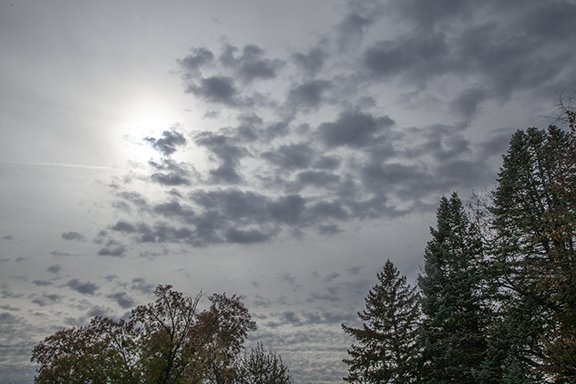
This photo shows two middle cloud layers present at the same time with each layer caused by different processes. The lower laayer is Altocumulus floccus, meaning the clouds are clumped like flocks of wool. Clear air is located above the Altocumulus. The altocumulus have formed near the top of a mixed layer of air. Vertical motions up and down in the layer have mixed it. The rising motion has created the individual cloud cells which are revealed by the clouds. The air is rising through the clouds and sinking around the he edges of the clouds in what looks like a patch of random cloudiness. Dryer stable air has limited the cloud depth to what is visible in this photo.
A higher Altostratus layer has formed in a sheet of rising motion and moisture. The upward motion is weaker in the Altostratus layer than in the cumulus clouds below. It is probably moving up at a few inches per second most likely induced by stronger winds aloft. Those winds produce alternating regions of upward and downward motions. If moisture is sufficient the coupled areas of up and down motion produce sheets of stratus type clouds that alternate with regions of downward motion where clouds are broken, scattered, or non-existent. That will be a topic for another time.